Deep Landscape

What do we actually know about the ground on which we stand, and how does it relate to our landscape projects?
Beyond surface
Interventions on the surface of the landscape affect the underground as much as they are conditioned by it.
Many processes pass through the grade of the ground, relating to water, energy, ecology and vegetation, with trees bridging above- and below grade. Organic matter is created in the ground, carbon is captured and stored there, and it is the habitat of various species. If we, as landscape architects, aim to incorporate ecology and hydrology [1] into project development, the design phase must incorporate a thinking of above- and below grade as one.
-

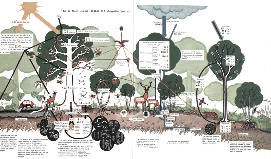
- In ecology, the deeper section has been central for showing the different ongoing processes: A diagrammatic section showing the forest ecosystem of upper Belgium from La synthèse écologique by Paul Duvigneaud, (1980: Illustration 11).
Design with water above- and below ground
Climate change affects the presence of freshwater around the globe. There is now less snowpack at higher altitudes, and as a result, a noticeable decrease in the replenishment of groundwater throughout the year. It is thus vital to work with the ground, retaining freshwater and slowing down its movement toward the ocean. Design with the groundwater is not new; 1000 years ago, Moors in Spain constructed ‘acequias’ to guide water. These irrigation canals slowed down the water and distributed it in the land below. On its way, water is absorbed into the soil, softening it, and replenishes aquifers and re-fills fountains. Design of this kind demands that we think on a territorial scale, incorporating the watershed, and also that we incorporate the depth of the landscape.
The planet is cooled to 95% through the heat dynamics of its water (only 4% corresponds to CO2). We are capable of handling this water by working with the ground and building up its living soils (Jehne, 2019).
The climate crisis means that there are new logics for water’s presence, with more frequent extreme events such as draught and flooding. To manage the water, we need to design with the water that is visible – which comprises only 1.2% of the earth’s freshwater – as well as the groundwater.
-
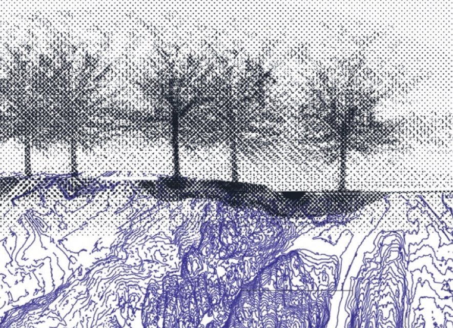
- An early illustration of the depth of the landscape reflecting above- and below grade with water, ground, atmosphere and vegetation (2015). Ill. Elisabeth Sjödahl
‘Blue-green’ and ‘brown’- infrastructure
The notion of blue-green infrastructure could be taken further in theory and practice through consideration of the depth of the landscape and its function as a blue-green and brown soil infrastructure. This function relates to the ground and its capacity to store water, to the building up of its soils and to carbon storage, as well as the need to consider and prevent land from erosion. Supplementing the concept of blue-green infrastructure with that of brown infrastructure would enrich it, indicating the significance of its depth for its performance.
Planning with the water and ground dynamics
Urbanisation modifies the ground on a larger scale. It changes both the ground and water and creates new environmental and urban conditions, for example, when impermeabilization prevents the groundwater from replenishing, or when freshwater extraction changes the groundwater levels, which can cause the ground to subside. Changing ground dynamics must therefore be addressed as part of future urban- and landscape projects.
Manmade grounds – from an exception to a rule in transformative projects
The reflections on the importance of a ‘deeper reading of the landscape’, including its humanmade ground conditions, started with a question in a design case: ‘How does one do a daylighting project on a landfill?
With human actions dominating the urban geological ground conditions, and the reuse and transformation of terrain is becoming an increasingly greater concern to limit greenfield development. Installations in the ground have often accumulated over time on previously urbanized land, meaning increased complexity.
This means that actively integrating the underground in the planning of urban transformation projects is more important than ever in order to prevent the underground installations from oversteering the design of the visual landscape. Equally important is the development of design strategies for the recovery of ‘manmade grounds’ [2] and water.
‘Deep landscape’
Our perception and understanding of our surroundings supply the framework for how we think and work. The notion of the ‘deep landscape’ [3] was formulated with the aim of bringing awareness to an otherwise overlooked relationship between the ground, water and human interventions, and deep landscape is a term, a theoretical concept, and a design strategy. The term deep landscape expands on Anne W Spirn’s concept of deep structures (Spirn, 1993). Spirn criticized urbanism for losing its relationship to its grounding conditions as its climatic, geomorphic, and biotic context. The deep landscape approach includes the manmade ground as found in archaeology. The term manmade ground is a combination of cultural and naturally occurring ground that archaeologist Matt Edgeworth defines as the ‘the archaeosphere’ (2014).
The term deep landscape also refers to an expanded physical and imaginary view of the landscape. ‘Deep time’ extends back to the creation of the geological context (Hutton 1788). Understanding time dimensions as a geological and planetary phenomenon is challenging and detached from human existence; deep time is so far in the past that it largely goes beyond ‘mortal time’. The term deep landscape acknowledges the unknown depth – not by precisely defining it, but by recognizing it as unmeasurable and by including its existence. When merging humanistic reading with science, it helps to go from science to sense and make incomprehensible and intangible time apprehensible.
-
- Illustration showing the processes that bridge the above- and below grade landscape: Water processes, infiltration, evaporation, temperature regulation, carbon fixation, decomposition and soil building. The vertical dimension reaches both downwards into the manmade underground and ‘deep geomorphic structures’ as well as upwards to include climatic layerings and biotic processes; i.e., it encompasses above- and below grade. Ill: Elisabeth Sjödahl.

Deep landscape is a reminder of the inseparable context beneath our feet, emphasising the underground landscape and promoting its incorporation into the design and planning of the visual landscape of the surface. It reframes landscape discourse and stormwater management practice. As a concept, it relates to the idea and principles that cover thinking about, working with, and perceiving landscape by bridging the divide between above- and underground. It is also a design strategy – a deep landscape approach to design in general that employs tools and landscape measures and foresees the underground interrelation in a project. A deep landscape design method has an ever-changing design perspective that oscillates between the surface and the underground in order to design with both and to balance and improve their interrelations.
-
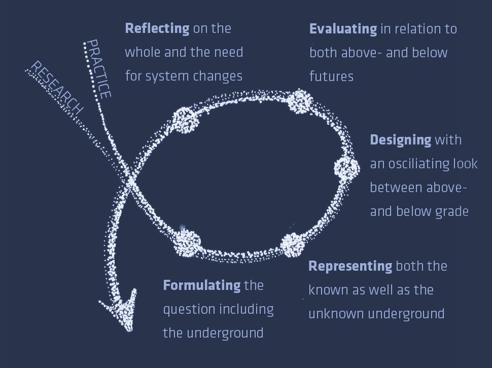
- Diagram of the ‘deep landscape’ as a design strategy and its different phases of: formulating, representing, designing, evaluating and reflecting, based on the design phases described by Lawson, B. (2004). ‘What Designers Know’ Ill: Elisabeth Sjödahl.
-
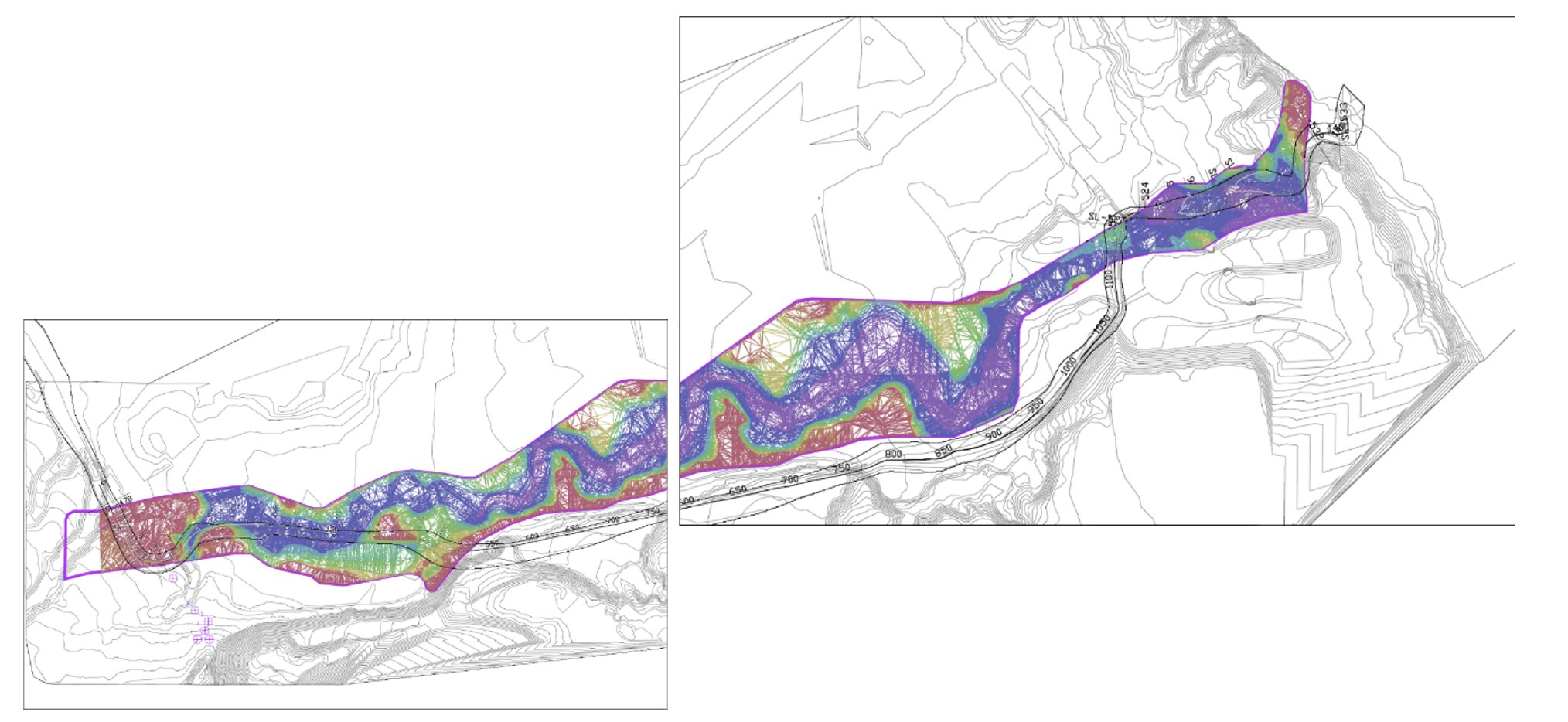
- Illustration of a ‘guess map’ made to estimate the magnitude of the waste deposit by subtracting the historical topographic map from today’s topography. From the daylighting project of Kjørbekk, Skien Municipality, Norway. Map: Multiconsult 2017.
Guess maps
Getting a good overview of the underground landscape is often a challenge in contemporary project development. If we don’t make representations of the unknown as hypotheses about natural or manmade ground however, it will never become part of the design process. Therefore, the best possible ‘guess map’ can be compiled using accessible information, like an interpolation and a conceptual drawing that define what is missing. Once the information is available in a visual form, other disciplines will be able to comment on it and approach the imaginary to reality.
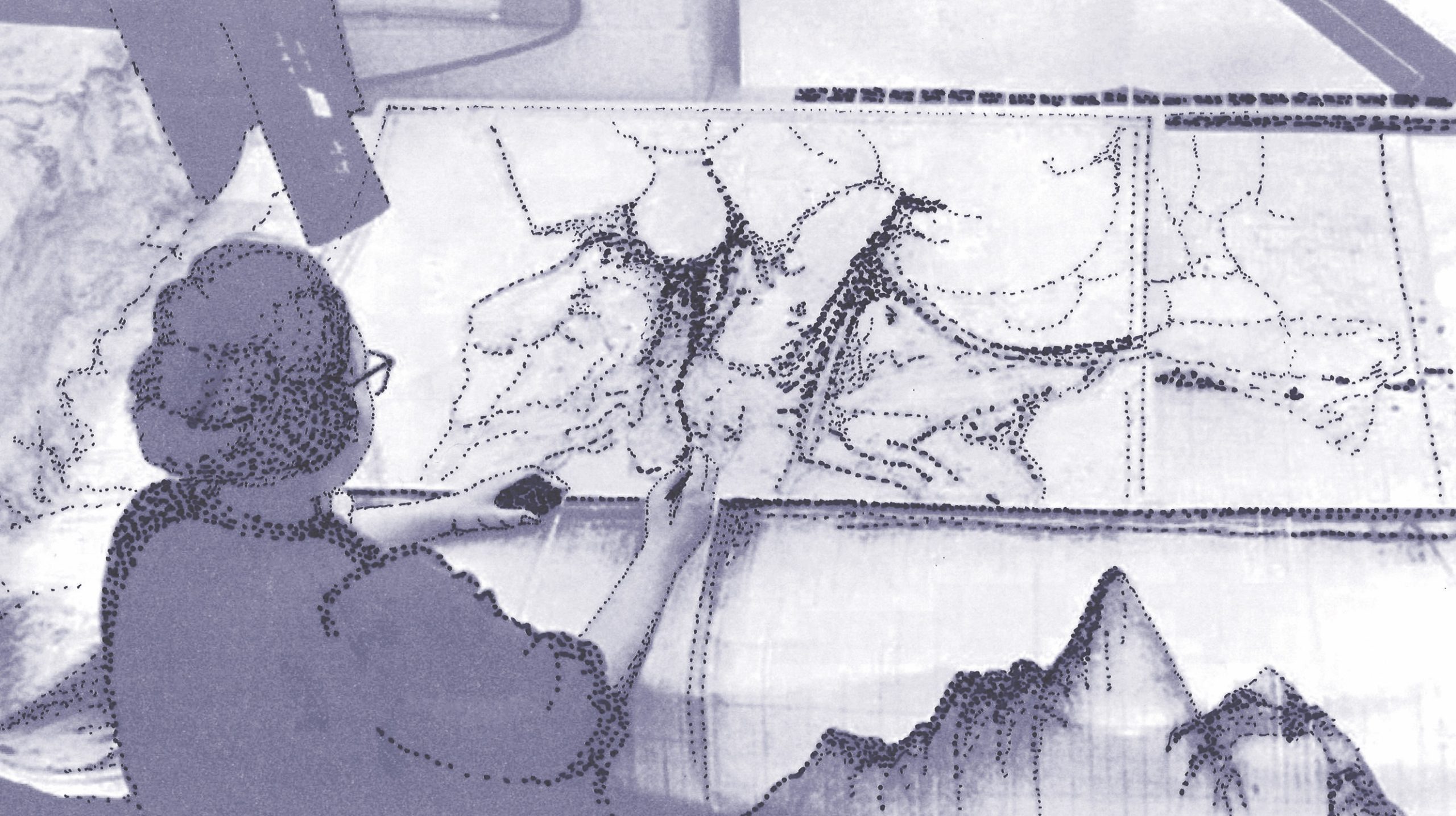
While working with a ‘guess’ may feel uncomfortable, working with hypotheses has historically been part of research seeking to define and understand more about our environment. Geographer Marie Tharp drew out the invisible in her groundbreaking work in the 1960s, defining what could not be seen on the bottom of the sea. Her work revolutionized the puzzle of the ocean floor by adding sections that together allowed a new reading, a comprehensive picture of the non-visible ocean floor.
-
- Geographer Marie Tharp, at work mapping the untravelled ocean floor. By adding sections, she enabled a completely new reading of the non-visible underwater ocean topography. Ill: Elisabeth Sjödahl. Based on Ph. From Lamont-Doherty Earth Observatory.
The underground as part of the project from the start
To summarize the humanmade ground in the era of the Anthropocene is more a rule than an exception in transformative projects, and it is becoming part of the design process. The notion of the deep landscape prompts inclusion of the ground with its imbedded history and all its relationships to the landscape in which we live. Landscape above- and below ground are connected through the processes that bridge them. The concept of the deep landscape is a way of perceiving, thinking and working with the landscape that goes beyond the visual surface and includes the landscape’s ground, depth and processes of change. Deep landscape as a design strategy includes the underground as part of the project from the start.
-
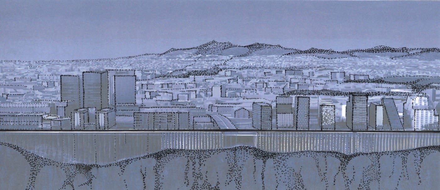
- Illustration of the underground constructions at the Oslo harbourfront. Section through the street Dronning Eufemias gate. A large part of the construction for buildings in this area is found underground to compensate for the poor initial ground conditions. Ill. Elisabeth Sjödahl. Based on digital model from Research project COST Sub-urban.
The ‘Deep Landscape’ is a design case-based thesis accessible at: https://hdl.handle.net/11250/3127964
For further discussions please contact: elisabeth.ulrika.sjodahl@aho.no
About the author

Elisabeth Sjödahl is landscape architect, architect and urbanist. She holds a landscape degree from the Technical University of Catalonia (UPC) Barcelona and an architectural degree from the École d’architecture de la ville et des territoires Paris-Est. She is currently a Professor at The Oslo School of Architecture and Design (AHO) and co-founder of a new landscape architecture program, a collaboration between AHO and UiT (winner of the international Ribas Piera School Prize, 2023). Past teaching at the Royal Institute of Technology (KTH) Stockholm and the Technical University of València (ETSA). She has experience from regional landscape planning, private practice and is a founding partner of the office Worksonland. She currently carries out multidisciplinary research that explores human cultural, water and ground relations across scales.
_________________
[1] Urban hydrology relates mostly to the landscape’s surface and whether or not it is permeable. Also necessary is the design with the interrelation and dynamics between water and ground, as their interrelation defines the ground conditions and water quality.
[2] The term ‘manmade ground’ is used in archaeology. There are living organisms in the ground that also modify it, and it is thus seldom completely manmade, but rather ‘modified by humans’ (Edgeworth, 2016). The term manmade ground is used here as it refers to larger human-produced changes to the ground, such as landfills and underground technical installations.
[3] The term deep landscape expands on Spirn’s concept of deep structures (Spirn, 1993). She distinguishes between deep structures, defined by geomorphic, climatic and biotic processes, and surface structures (natural and human-modified). The manmade ground has in the age of the Anthropocene reached such complexity that it can steer the development of the visible and lived landscape as well as affecting the deep structures, defined by Spirn, with its own force.
Published on December 2, 2024


